| Volume
72
1 July, 2002
Isla Espiritu Santo, Isla Partida, Isla San Francisco & Isla
San Jose
!!!! The
Two Captains Start their Fourth Year of Cruising !!!!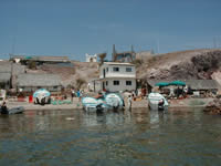
The
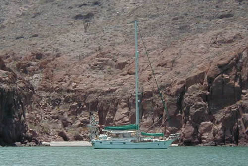
afternoon of June 8, we sailed (really!!) out of La Paz a short,
five-mile hop to Caleta de Lobos which meant we were able to celebrate
the eve of our third anniversary since leaving St. Thomas at anchor
instead of in a slip!!! (June 9, 1999 - St. Thomas; June 9, 2000
- Trinidad; June 9, 2001 - Galapagos; June 9, 2002 - Baja!) We got
the hook down early enough in the quiet afternoon to test paddle
the new kayak and have a nice dinner with a bottle of wine. Thanks
to this latter, we slept fairly well through the Corumuel winds
that night, but perhaps the wine bears some responsibility for our
somewhat less that clear thinking the next morning.
 For
the winds were still cranking when we set off on a 17 mile reach
to Isla Partida, and as though the three years of cruising experience
since our old charter boat days in the VI had simply evaporated,
we set off towing the dinghy and outboard instead of hoisting both
aboard. Wow, between the wind and the fresh bottom paint, Tackless
II flew across the 4-5 foot seas of the San Lorenzo Channel making
7.5 to 8 knots! This would have been exhilarating if it hadn't been
for the dinghy surfing down the face of these same waves, threatening
to pass us, before being yanked back around. Unfortunately, we were
committed, but fortunately Mother Nature was forgiving and we pulled
into Caleta de Partida without having swamped the dinghy or motor. For
the winds were still cranking when we set off on a 17 mile reach
to Isla Partida, and as though the three years of cruising experience
since our old charter boat days in the VI had simply evaporated,
we set off towing the dinghy and outboard instead of hoisting both
aboard. Wow, between the wind and the fresh bottom paint, Tackless
II flew across the 4-5 foot seas of the San Lorenzo Channel making
7.5 to 8 knots! This would have been exhilarating if it hadn't been
for the dinghy surfing down the face of these same waves, threatening
to pass us, before being yanked back around. Unfortunately, we were
committed, but fortunately Mother Nature was forgiving and we pulled
into Caleta de Partida without having swamped the dinghy or motor.
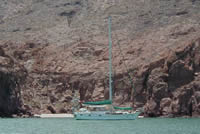
Isla Espiritu
Santo and Isla Partida, the two islands that project northward to
define the Bahia de La Paz's east side, fit so closely together
like pieces of a jigsaw puzzle, that they may as well be one island.
Regardless of how many very different regions we have traveled through,
our many years in the Virgin Islands inclines us to look at a string
of deeply inset bays open to the west and see nice protected anchorages.
Wrong! No longer are we in the land of winds out of the east. Take
these two islands and plop them in the VI and they would offer at
least ten great stopovers. Here, at this time of year, you've got
instead ten wind scoops lying wide open to the southwesterly Corumuels!
No wonder the Moorings bareboat business has never really taken
off here!!!
 Caleta
de Partida, the "bay" formed where the two islands nearly
interlock, had the best reputation for protection from the Corumuels.
Clearly that is Caleta
de Partida, the "bay" formed where the two islands nearly
interlock, had the best reputation for protection from the Corumuels.
Clearly that is 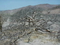 relative.
We swooped in to find three boats already squeezed as tightly as
imaginable in the dubious lee of a big bulge of rock. This left
their sterns in fairly shallow water with more shallow water behind.
Yikes! We made a spot for ourselves, blessing our relatively shoal
draft, and let out enough scope for a hurricane! We zipped up our
dodger and side windows, added a layer or two of clothing and essentially
hunkered down to wait it all out. Okay, I exaggerate….slightly.
It did not blow like stink for 24 hours a day. Just about nineteen
or twenty. And I'm sure it only FELT like it was freezing. What
is the wind chill factor for 69 degrees x 25 knots? I do not exaggerate
to say that we wore our many warm layers until broad noon. In the
afternoon's four-hour "window" of relative "calm,"
however, we did venture off the boat to explore the small "channel"
that wends its way between the two islands. What a great set-up
for the fishing camp on the sand bar, access to both sides of the
two islands without having to take the long way round! For us, the
sand bar offered up a great beach walk with piles of shells to study. relative.
We swooped in to find three boats already squeezed as tightly as
imaginable in the dubious lee of a big bulge of rock. This left
their sterns in fairly shallow water with more shallow water behind.
Yikes! We made a spot for ourselves, blessing our relatively shoal
draft, and let out enough scope for a hurricane! We zipped up our
dodger and side windows, added a layer or two of clothing and essentially
hunkered down to wait it all out. Okay, I exaggerate….slightly.
It did not blow like stink for 24 hours a day. Just about nineteen
or twenty. And I'm sure it only FELT like it was freezing. What
is the wind chill factor for 69 degrees x 25 knots? I do not exaggerate
to say that we wore our many warm layers until broad noon. In the
afternoon's four-hour "window" of relative "calm,"
however, we did venture off the boat to explore the small "channel"
that wends its way between the two islands. What a great set-up
for the fishing camp on the sand bar, access to both sides of the
two islands without having to take the long way round! For us, the
sand bar offered up a great beach walk with piles of shells to study.
 After
two days we'd had enough of this, so despite little sign of improvement,
we moved north four miles to Ensenada Grande. Whether there was
a coincidental improvement in the weather pattern or whether we
just got a little farther away from La Paz, I'm not sure, but we
found a delightful haven in a one-boat niche off the southern After
two days we'd had enough of this, so despite little sign of improvement,
we moved north four miles to Ensenada Grande. Whether there was
a coincidental improvement in the weather pattern or whether we
just got a little farther away from La Paz, I'm not sure, but we
found a delightful haven in a one-boat niche off the southern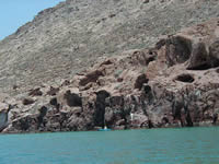 lobe of this three-lobed bay. Here, it got a little warmer a little
earlier in the day, and the windless window lasted a little longer.
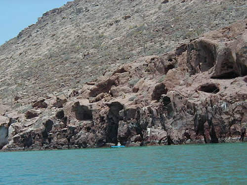
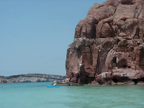
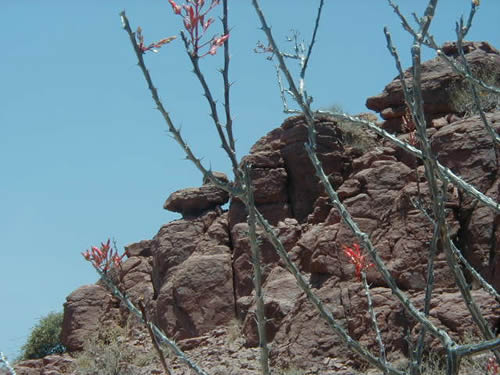
It was also the perfect place to kayak. What rocks!!! While the
surface of the hilltops looked as smooth as a crust on a cake, where
the cliffs have been cut by the sea is revealed a whole turmoil
of geologic action. On one side the point looked like some under-cooked
baker's confection! The cliffs sagged like things hadn't quite set
and gaseous bubbles had left honeycomb-like pockets in the overhangs!
lobe of this three-lobed bay. Here, it got a little warmer a little
earlier in the day, and the windless window lasted a little longer.
It was also the perfect place to kayak. What rocks!!! While the
surface of the hilltops looked as smooth as a crust on a cake, where
the cliffs have been cut by the sea is revealed a whole turmoil
of geologic action. On one side the point looked like some under-cooked
baker's confection! The cliffs sagged like things hadn't quite set
and gaseous bubbles had left honeycomb-like pockets in the overhangs!
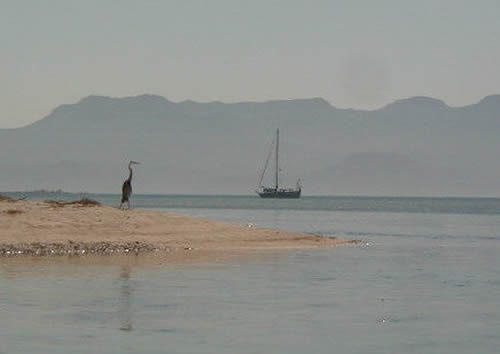
On the other
side the long arm of the bay looked like the many layers of an English
trifle, there were so many strata of rock!. The water was variably
clear so in some spots one could peer down from the kayak at tropical
type fish below, but it was way too chilly for taking more than
a very quick plunge from the back of the boat. The only life we
saw, other than a Great Blue  Heron,
who coolly watched me paddle by, were scores of little crabs making
the most of the tidal drop. Heron,
who coolly watched me paddle by, were scores of little crabs making
the most of the tidal drop.
When two small
powerboats squeezed in with us in our one-boat corner --before coffee,
mind you --, we picked up the anchor and moved on. Our  original
plan was to motor the few miles northeast to Las Islotes to check
out the sea lion colony there, but the wind was chilly and the sea
choppy (and of course we had gotten a good dose of sea lions in
the Galapagos), so we opted instead to sail on the 19 miles to tiny
Isla San Francisco. Since we missed our shot to see sea lions, Mother
Nature sent us instead our first Baja whale. Although quite close
to us, it made no leaps or tail-flipping dives to give us any clue
to identification, but it puffed past spouting repeatedly, so we
were quite pleased. Mother Nature clearly figured she'd done enough,
and we caught nada on our trolling lines. However, things were about
to look up in the seafood department. Our friends Lourae and Randy
of Pizzazz cruised into the charming hook-like anchorage at San
Francisco with a 50-inch dorado (mahi mahi), so we enjoyed not only
a great dinner, but evidence that there are indeed some fish to
be caught in the Sea. (Red lures….do we have any red lures?) original
plan was to motor the few miles northeast to Las Islotes to check
out the sea lion colony there, but the wind was chilly and the sea
choppy (and of course we had gotten a good dose of sea lions in
the Galapagos), so we opted instead to sail on the 19 miles to tiny
Isla San Francisco. Since we missed our shot to see sea lions, Mother
Nature sent us instead our first Baja whale. Although quite close
to us, it made no leaps or tail-flipping dives to give us any clue
to identification, but it puffed past spouting repeatedly, so we
were quite pleased. Mother Nature clearly figured she'd done enough,
and we caught nada on our trolling lines. However, things were about
to look up in the seafood department. Our friends Lourae and Randy
of Pizzazz cruised into the charming hook-like anchorage at San
Francisco with a 50-inch dorado (mahi mahi), so we enjoyed not only
a great dinner, but evidence that there are indeed some fish to
be caught in the Sea. (Red lures….do we have any red lures?)
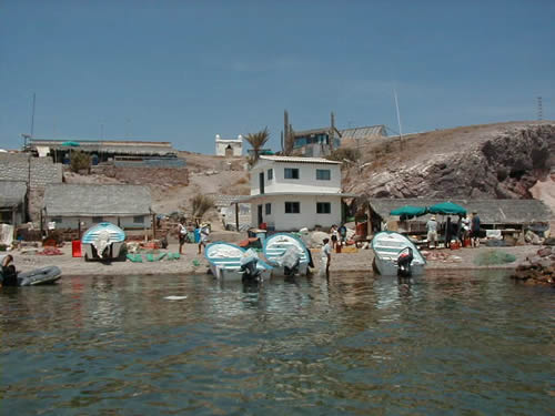
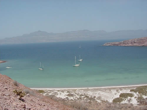
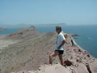
 Isla
San Francisco, though tiny, is another great spot. (Can you tell,
our enthusiasm is picking up!) It has a great long curving beach
to walk, and a hike up and along the encircling ridge. We did both.
The hike was our first in Isla
San Francisco, though tiny, is another great spot. (Can you tell,
our enthusiasm is picking up!) It has a great long curving beach
to walk, and a hike up and along the encircling ridge. We did both.
The hike was our first in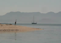 the desert. I wonder if we will ever get jaded to variety of color,
shape and texture of the rock here. On the far side of the ridge
there were veins of green while below lay copper colored beaches.
The desert ground beneath our feet seemed like incredibly hostile
soil, and yet the variety of life struggling to survive amazed us.
There were dozens of low shrubs, stunted trees and different cacti.
My favorite was a thorn trees - called Palo Adan or Adam's trees
(identified after the fact from a friend's Baja Plant Field Guide
- which had delicate red flowers at the tips of its leafless branches
around which -- believe it -- buzzed a hummingbird! Walking was
easy on the crunchy surface, very reminiscent of frost on grass
in feel and sound, while clambering up rocks required great attention
as most of it was loose and crumbly.
the desert. I wonder if we will ever get jaded to variety of color,
shape and texture of the rock here. On the far side of the ridge
there were veins of green while below lay copper colored beaches.
The desert ground beneath our feet seemed like incredibly hostile
soil, and yet the variety of life struggling to survive amazed us.
There were dozens of low shrubs, stunted trees and different cacti.
My favorite was a thorn trees - called Palo Adan or Adam's trees
(identified after the fact from a friend's Baja Plant Field Guide
- which had delicate red flowers at the tips of its leafless branches
around which -- believe it -- buzzed a hummingbird! Walking was
easy on the crunchy surface, very reminiscent of frost on grass
in feel and sound, while clambering up rocks required great attention
as most of it was loose and crumbly.
After two nights
at "The Hook", we moved around to the island's north face,
where notes in the margin or our cruising guide suggested lobsters
could be found in the rocky reefs. Well, we're sure they're there
as the beach was littered with molted shells, but the water is still
way too cold for US to hunt them. Perhaps we'll check it out on
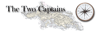
our return leg. Instead we dinghied about a mile across to Isla
Coyote, the smallest inhabited island in the 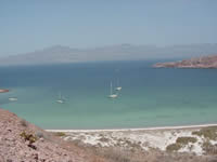 Sea
of Cortez, where word was we could BUY some lobster. No typical
fishing camp this, the houses on this piece of rock are all substantial
block homes belonging to the four generations of a single family
that have lived there since the 1920s. We found the brothers in
the midst of filleting stingray and manta ray, so we had the time
to look around a bit. Then we Sea
of Cortez, where word was we could BUY some lobster. No typical
fishing camp this, the houses on this piece of rock are all substantial
block homes belonging to the four generations of a single family
that have lived there since the 1920s. We found the brothers in
the midst of filleting stingray and manta ray, so we had the time
to look around a bit. Then we 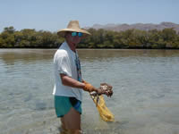 were
taken by panga to their cache of lobster kept on the cooler cleaner
side of the islet. No deals here, unfortunately, but after all the
bother we took two for supper, our first lobster since the San Blas
of Panama. Our next stop was only a few miles further north a La
Amortajada ("The Shroud"), another hook-like anchorage
at the southern end of Isla San Jose, only much bigger! Ironically,
many boats skip this stop, or just make a daytime visit, because
it has a reputation for bad no-see-ums. Miraculously, we had none,
so we stayed several days, and it is surely one of our favorite
spots so far. Protection is provided by a long curving spit, that
we made the mistake of assuming was sand. It's not. It's a 8-10
foot high bank of packed stones and shells, that looks as man made
as can be, but, of course, isn't! Although billed as "good
shelling", most of the shells we saw when walking on this bank
were well aged and bleached. were
taken by panga to their cache of lobster kept on the cooler cleaner
side of the islet. No deals here, unfortunately, but after all the
bother we took two for supper, our first lobster since the San Blas
of Panama. Our next stop was only a few miles further north a La
Amortajada ("The Shroud"), another hook-like anchorage
at the southern end of Isla San Jose, only much bigger! Ironically,
many boats skip this stop, or just make a daytime visit, because
it has a reputation for bad no-see-ums. Miraculously, we had none,
so we stayed several days, and it is surely one of our favorite
spots so far. Protection is provided by a long curving spit, that
we made the mistake of assuming was sand. It's not. It's a 8-10
foot high bank of packed stones and shells, that looks as man made
as can be, but, of course, isn't! Although billed as "good
shelling", most of the shells we saw when walking on this bank
were well aged and bleached.
 Granted
we didn't walk super far, as the odor was very strong. What we did
see were many fish skeletons, including the entire spine of a dolphin
or small whale! Don was itching to take this home, but at a good
seven feet long, it was it or me! Behind this bar is a large mangrove
lagoon. This mangrove estuary is the real highlight Granted
we didn't walk super far, as the odor was very strong. What we did
see were many fish skeletons, including the entire spine of a dolphin
or small whale! Don was itching to take this home, but at a good
seven feet long, it was it or me! Behind this bar is a large mangrove
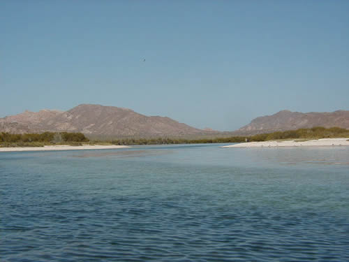
lagoon. This mangrove estuary is the real highlight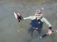 of La Amortajada. The entrance, once the sand bars are negotiated,
unfolds into a "river" estuary that serpentines in a mile
or so to a wide lagoon. In the lagoon proper, the area is so large
and the water so calm, that some of the big powerboats come in here
with their guests for water skiing! As you might guess this estuary
attracts many birds. We saw herons of several types and nesting
frigatebirds, among others, not to mention many, many seagulls.
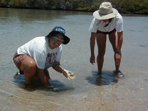
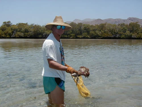
The mangrove roots are home to many fish, and when the tide uncovers
the several sandbars at either end, a whole wealth of shellfish
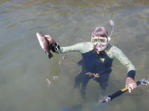
is uncovered, including steamer clams and pen scallops. We made
our debut in the collecting of these, learning the ropes from several
experienced Baja cruisers, and Don also made his first forays with
his new spear gun. Fortunately, the fish had a lower learning curve
than he did and we got two for supper!
of La Amortajada. The entrance, once the sand bars are negotiated,
unfolds into a "river" estuary that serpentines in a mile
or so to a wide lagoon. In the lagoon proper, the area is so large
and the water so calm, that some of the big powerboats come in here
with their guests for water skiing! As you might guess this estuary
attracts many birds. We saw herons of several types and nesting
frigatebirds, among others, not to mention many, many seagulls.
The mangrove roots are home to many fish, and when the tide uncovers
the several sandbars at either end, a whole wealth of shellfish
is uncovered, including steamer clams and pen scallops. We made
our debut in the collecting of these, learning the ropes from several
experienced Baja cruisers, and Don also made his first forays with
his new spear gun. Fortunately, the fish had a lower learning curve
than he did and we got two for supper!
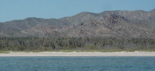
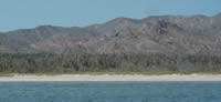 Another
attraction of this bay is an extensive "forest" of Cardón
cactus. The Cardón cactus is the tallest cactus in Baja.
Walking through a forest of them, is much like walking through a
"forest" of telephone poles as they are mostly straight
with few branches. Of course, there are many other varieties of
plants and cacti going between them, but that's the only one I was
definite on when I got back to the plant guide. Another
attraction of this bay is an extensive "forest" of Cardón
cactus. The Cardón cactus is the tallest cactus in Baja.
Walking through a forest of them, is much like walking through a
"forest" of telephone poles as they are mostly straight
with few branches. Of course, there are many other varieties of
plants and cacti going between them, but that's the only one I was
definite on when I got back to the plant guide.
Perhaps the
biggest problem with our time in this stretch of Baja is the constant
mental tug-of-war between the pleasure of just being in these special
spots, and the lure of what lies farther on ahead. It was hard to
tear ourselves away, but after a quick overnight or two across the
channel off the somewhat bleak fishing village of Evaristo, we popped
the genoa and sailed north forty miles to a bay we had been hearing
about since the Caribbean -- Aqua Verde.
|