HOME |
LOGBOOK |
|
We didn't leave "The Rock" that night either, and the boys didn't get us any grouper. While there were a few fish down there, there were dozens of LARGE barracuda, shadowing us like street gangs, which definitely dampens the enthusiasm for hunting, especially with no dinghy along to put the catch in. We did in fact leave at 0230 Friday the 13th. Now does that bespeak secure people? There were four boats that left in staggered departure times according to their self-perceived speeds. It was the full moon, so it was a spectacular night. The winds were actually a little light for us, and from dead astern, so we had to tack downwind, somewhat of a pain with the whisker pole, but the seas state was down, which was one of our big objectives.
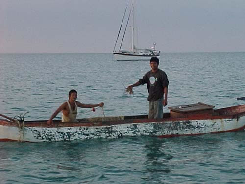
There is very little development along this coast until you come to Bahia de Portete which we understand is a coal-loading operation. Outside the Bahia we came upon a designated ship anchorage where we sailed right through five huge transports, an eerie feeling! Cabo de Vela was an impressive
headland. There was a rock that was essentially a glossy black pyramid
rising from buff-colored bluffs, almost impossible to capture on
film. The seas got steeper and the winds steadily increased along
a couple of miles of cliff. We had steadily furled the genoa smaller
and smaller down to a quarter of its whole actually trying to reduce
our speeds, before we finally rounded into a cove through a huge
school of yellow, globular jellyfish, and there is nothing quite
like bringing the bow into a roaring wind after a long downwind
trip. Wow! All four boats arrived within an hour or so of each other. At first the cove did not seem hospitable, the hillside a harshburnt umber with littlevegetationand a stark lighthouse. But the sunset was gorgeous, the moonrise even more so, our fresh fish supper yummy, and gradually the winds lightened. By morning the place seemed positively gentle. Through the night, several motorized canoes (with one-lunger engines; they don't sneak up on you) of fisherman set nets among us. During coffee, two of the boat stopped by to offer us fish or lobster, but we were stymied by no idea on either side of the exchange rate between Colombia pesos and UD dolares. Really we needed no fish, but the attempt to chat with the fishermen seemed to be enjoyable for all. Even my pequeno bit of espanol gets us somewhere! Our weather window is superb, and the moon still full, so all four of us will move out this afternoon for the 120-mile, overnight leg to Bahia Cinto, a series of five picturesque bays just north of Santa Marta, a real town! From there it will take us a half day plus two more full days to reach Cartagena, so we may linger awhile at this next stop. After all, although we are eager to have this journey done with, we are NOT hyper to get back to an urban setting. |
|
home
| waypoints | logbook | reference shelf
|