|
HOME |
LOGBOOK |
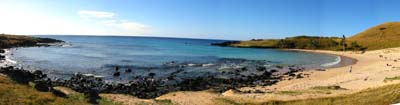
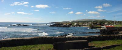
| 2C Update #119 Easter Island to us, it is Île de Paques to the French in the airport at Papeete, Isla de Pascua in the official Spanish of Chile, the country to which it belongs, and Rapa Nui to the people who live there. It is also called by the natives Te Pito o Te Henua, the Navel of the World. The farthest and loneliest outpost of Polynesian culture, this 180 square kilometer island sits all by itself in a vast expanse of ocean. Its closest neighbor is the even smaller Pitcairn Island, a lonely rock in its own right, 1900 kilometers to the west.
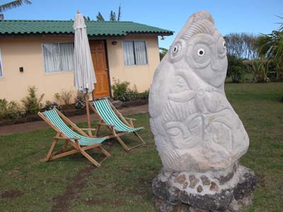
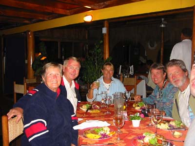
Although Easter Island is connected politically with Chile 2,294 miles to the east, its people are spiritually and culturally more strongly connected to Tahiti 2,517 miles to the northwest. Lan-Chile Airlines makes those connections real by flying thrice weekly to Easter Island as a stopover between Papeete and Santiago. Because July, August and September are the high season in Tahiti, travel to Easter Island from Papeete peaks during those same months, even though it is the island’s coolest season. Although most of the travelers are French tourists in the midst of their summer holidays, cruisers, looking to leave French Polynesia to renew their visas, make up part of the flow. We were joined on the plane by Canadians Sandra and Dennis Nagy of Blue Heron 2000 and the hitch-hiking single yachtmaster Callie Logsdon, all of us on the same affordable three-night/four-day package. We all had to go somewhere to renew our visas, but what drew us all to make this particular six-hour flight was of course the mystery of the moai, the “big head” statues we’ve all seen looking out at us from the pages of National Geographic and the like. Our flight, which left Papeete rather inconveniently at midnight, arrived in Easter Island rather more conveniently at nine thirty on a bright sunny morning on a huge long runway that crosses the southern neck of the island from one coast to the other. We later learned the runway was built by the US as an alternate landing site for the shuttle! Greeted at the airport with leis by staff from our pension, we climbed into the pension’s two mini-busses for the short drive to the Cabañas Vai Moana ( HYPERLINK "mailto:vai_moana@entelchle.net" vai_moana@entelchle.net). The attractively low-key pension, located just north of Hanga Roa, Easter Island’s only town, had moai replicas out front and modern Rapa Nui sculptures on the lawn out back. Our clean and simple room featured a very comfortable bed, on which we promptly snatched a most welcome nap before our first luncheon and first tour.
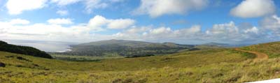
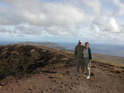
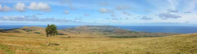
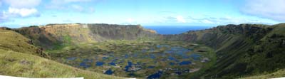
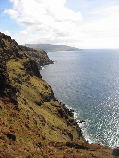
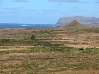
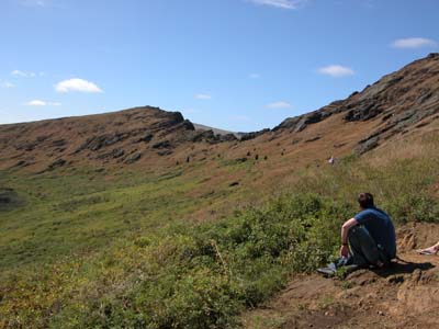
Since two-thirds of the guests at Vai Moana were French, we were quite relieved to find that an English-speaking guide had been provided for us in the attractive and personable Rosita Mazuela Hucke. Rosita, we were to learn over the next few days, was like a microcosm of the island itself. Born of a Chilean father and Rapa Nui mother, Rosita learned English when archaeologist JoAnne Van Tilburg took her as a youngster for five years education in the States. Making her living as a tour guide now, she is fiercely loyal to the island and its culture, but like many young people she is frustrated by its smallness, and spend all the time she can in French Polynesia. I am sure we were all eager to see our first “big heads”, but that was not to be. That first afternoon’s excursion took us up to the rim of Rano Kau volcano, the southernmost tip of the island. Rano Kau’s huge lake-filled crater was clogged with reeds and other plants that have been important to the Rapa Nui people through the ages. It was also a good spot to get oriented to Easter Island’s triangular layout. Away to the east is Poike, which was the first of the three main volcanoes to “pop up”from the sea floor some 3 million years ago. To the north is the last and highest – Terevaka – which along with 70 smaller cones filled in the middle of the island. The rest of the landscape is rolling grassland, dotted by clumps of eucalyptus trees that have been planted in modern times to relieve the island’s treeless-ness, All around is the sea
On the edge of Rano Kau, looking out over the crater’s eroded seaward edge, Rosita explained how the first explorers to the island – scouts send out by King Hotu Matu’a – having sighted the island from the southwest, climbed onto it over this ridge. The oral tradition of Easter Island has it that the first settlers followed those scouts to the island in a migration led by King Hotu Matua, probably from the Marquesas, around 400 AD. This is important because it introduced the fundamental principal that Easter Island was settled by people who traveled eastward, against the prevailing winds and current, just as they had done from their earliest origins in southeast Asia. Descendants of those earliest peoples (known to historians as Lapitas), the Polynesians of Samoa and Tonga set out even furher eastward to colonize the Societies, the Marquesas and the Tuamotus 200 years before the birth of Christ. Six centuries later, in the same period that Hotu Matu’a was crossing the vast distance to Easter Island, other Polynesia explorers were voyaging equally as far afield to Hawaii and New Zealand. Coming from the west is hard for sailors to accept, oriented as we are to sailing WITH the wind and currents, as we all had just done from Mexico and Panama. To sailors it seems far more logical that settlement of such a distant outpost would have come downwind from South America, and Thor Heyerdahl’s many books along with his 1947 Kon Tiki expedition which have sought to prove that theory, hold some appeal.
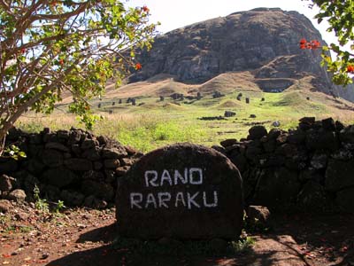
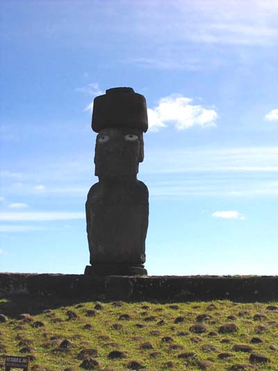
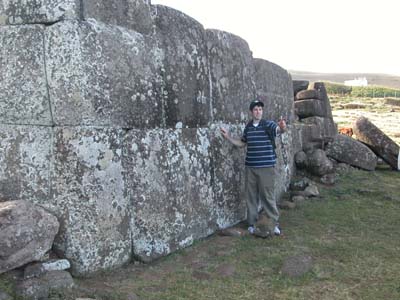
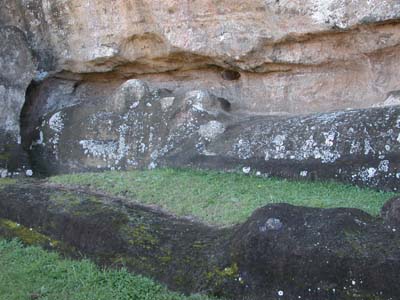
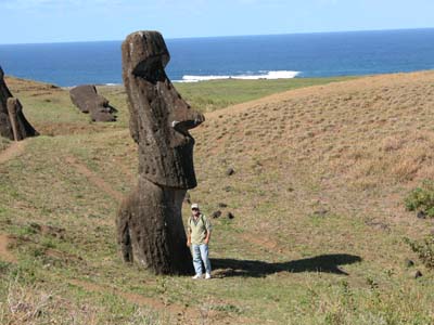
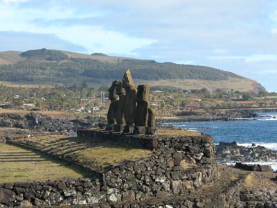
But Polynesians were not sailors; they were paddlers. The traditional strategy of Polynesian voyaging was to paddle INTO the wind and current navigating by the stars while following the clues given by seabirds’ daily migrations, watching for reflections of land on the undersides of clouds, and reading the diversions in waves and currents made by islands interrupting the stream. Then, if the voyage went sour, they could count on drifting back home! Rosita insisted we get this straight right at the outset, making it very clear that most of the evidence –linguistic analyses (Rapa Nui is quite close to Tahitian), archeological and anthropological studies, and even genetic tests – supports the oral tradition. Similarly she would have us wipe away any associations of mysticism in our experience of the moai. The Rapa Nui people, her people, did not need aliens to create or erect the giant statues. Nor, as we found out the next day on our first exposure to the giant statues, What were the moai? Current belief has it that the moai were carved tributes to important people in the various tribes of Rapa Nui during the “classic era” of its history, 800AD to 1680. With each moai erected on the clan’s ahu (an important ceremonial platform oriented to look over the village), the “mana” or “spiritual force” of that clan was strengthened. The “heads” themselves were all carved from volcanic tuff from one quarry at the small volcano Rano Raraku while their red rock pukao, or topknots (various described as hair or hats) were carved from a completely different quarry on the other side of the island.
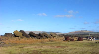
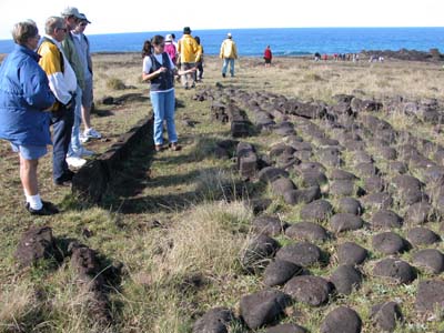
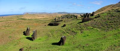
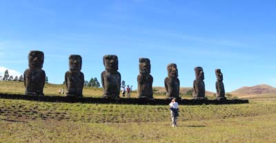
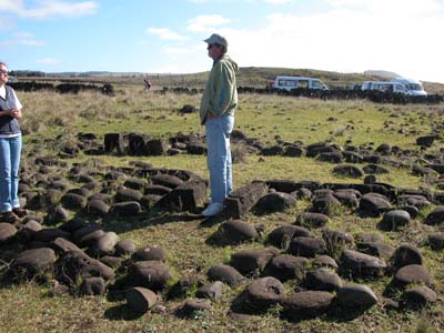
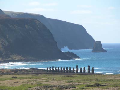
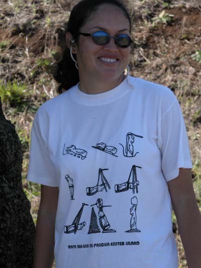
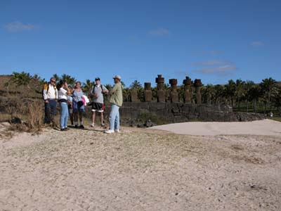
If there is one single thing about Easter Island that impressed us most, it would be the Rano Raraku quarry and that statistics that go with it. According to archaeologist Jo Anne Van Tilburg, an average moai was four meters tall and weighed 12.5 metric tons. The largest moai ever erected was 9.8 meters tall and weighed some 74 metric tons. An even larger moai, one that is 21.6 meters long still lies in the rock of the quarry. Of the 887 moai so far identified and catalogued, only 288 ever made it to their ahu, while almost 400 never left the quarry at all. These can be seen on the slopes of the volcano in all the various stages of production. There are many still lying head-to-toe only partially carved out. Others have been removed from the rock but stand with their backs yet uncarved. Still others seem all but finished except for their eye sockets, a final step that was only taken once they were erected on the ahu. How they were transported is not known for certain. A popular T-shirt worn by Rosita illustrates the five theories proposed by as many archaeologists. Ninety-two still lie willy-nilly across the countryside, abandoned for some reason on their way out. On the map in the tourist pamphlet I count 26 ahu. Of all these, there are only a few where the moai have been re-erected by various organizations from various countries. Other than the ones in Hanga Roa’s downtown park, the most impressive restorations are Ahu Nau Nau, where the moai had been buried in sand and therefore protected from the elements; Ahu Tongariki with its lineup of fifteen statues; and Ahu Akivi, the only ahu not on the coast, whose seven moai are said to represent the seven explorers sent out by King Hotu Matu’a. Of these only four of the moai at Ahu Nau Nau, one at Tongariki, and lone figure at the park have their pukao in place. The one at the park is the only one to have eyes, and that took a vote of the town council to restore them! All the rest of the moai, all around the island, lie face down or broken.
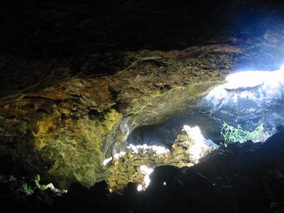
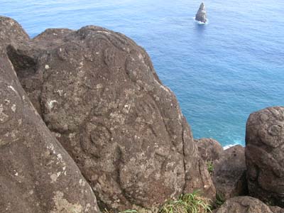
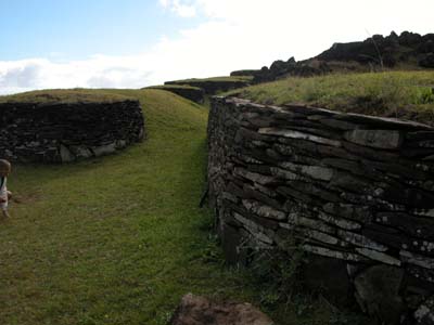
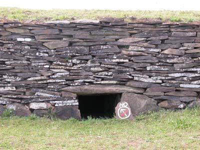
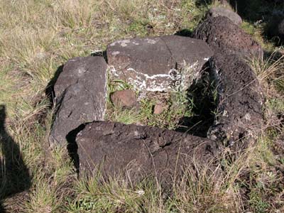
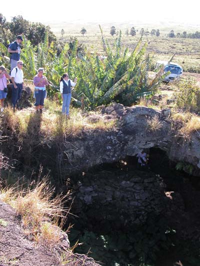
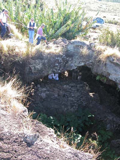
This is not all that Easter Island has to offer. There are hundreds of petroglyphs across the island where Rapa Nui man carved out images of things he saw. There are the foundations of villages with their Hare Paenga (boat shaped houses) and umu (stone ovens). There are underground caves left by lava tubes where people hid during times of war. There are the haunting tablets of Kohau Rongo Rongo, a hieroglyphic type writing whose meaning was lost when the last scholars were carried off by Peruvian slavers. And there is the intriguing Bird Man cult (Tangata Manu) which rose up as the moai were toppled with its unusual ceremonial village perched on the rim of Rano Kau that we visited the first afternoon. All this we saw in our three days of touring To even try to describe it all would take a book. All this and there was some free time left over. One evening Rosita urged us to stop by an umu, the Rapa Nui version of the earth-baked pig roast. This umu was not a tourist event, but rather a community fund-raiser for a local woman getting medical care on the mainland. It featured huge platefuls of food and three great bands. I was very keen to hear as much Rapa Nui music as I could. I’d got my first taste of it checking in at Hiva Oa when the bank teller was playing it on his boom box, and I was determined to bring home as many CDs as I could. I was hugely disappointed to discover that the much-touted weekly performance by the group Kari Kari at the towns biggest hotel would not take place the week we were there as the group was in Palau at the annual Pacific Arts Festival! But our own pension soothed the disappointment by bringing in a smaller group who performed traditional songs and dances during our aturday dinner. The other place to find Rapa Nui music is in church, and to do so four of us went to Sunday mass, where all the congregations responses were sung!
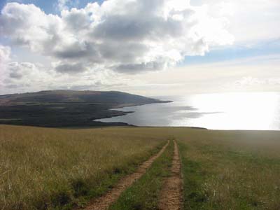
On our afternoon off, Don walked to the harbor hoping to get in a scuba dive (he didn’t) while I went off with Cally for a wild and wooly horseback ride to “la punta mas alta” (aka, the highest point) atop Mount Terevaka. Much of the three-hour ride was off road, cantering through open fields with island-wide panoramic vistas or jogging down narrow trails through out of the way terrain. As always there is nothing that matches horseback as a way to see the real countryside…nor nothing to match the agony of the body once you get off. All in all it could hardly have been a nicer trip. The weather, if a bit cool for these tropical bones, was mostly fine all three days; the company (including the French folk) congenial, the service of the pension just fine, and the bed (always an important thing to us) divinely comfy. Plus, we can’t say enough about our great guide. Rosita’s earnest enthusiasm for this land of her ancestors filled us with respect for all we saw, and her patience in fielding all our questions deserves an award. In sum, it is a very worthwhile trip for anyone, but in particular for cruisers who find themselves in Tahiti. However far-flung, however influenced by modern Chile, Rapa Nui is such a strong reflection of the Polynesian culture we are seeking farther north that it really shouldn’t be missed. And, believe me, although it was sobering to undo in one flight all the degrees of westing so hard earned in our month’s passage from the Americas (Easter Island is the same longitude as La Paz, Mexico!), flying is the way to go there, not by boat. Other than the tiny town boat basin where lighters unload cargo from passing freighters, there is virtually no anchorage for boats that offers any kind of protection. Although there are those that do, to sail down all that way against the off chance of enough good weather to do the place justice would, in our view, be a hell of a waste..
|
||||||||||||||||||||||||||||||||||||||||||

|
home
| waypoints | logbook | reference shelf
|